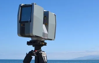


Mobile Mapping and Aerial LIDAR
Our mobile mapping and aerial Lidar services are designed to collect 3D data of large-scale environments, such as transportation infrastructure, urban areas, and natural landscapes. Our Lidar sensors are mounted on vehicles or aircraft, allowing us to capture data at high speeds while maintaining accuracy and precision.
- Transportation: road condition assessment, traffic flow analysis, and pavement evaluation
- Urban planning: city modeling, zoning analysis, and land use planning
- Environmental monitoring: floodplain mapping, wetland delineation, and vegetation mapping
- Surveying: boundary mapping, property appraisal, and utility mapping
- Public safety: crime mapping and emergency response planning
Mobile Mapping and Aerial LIDAR
It works by emitting rapid pulses of laser light and then measuring the time it takes for the light to bounce back after hitting a surface, which allows it to create precise measurements of distance and create detailed 3D maps of terrain, buildings, and other objects.
NASA used LiDAR in their landing procedures to analyze the surface of the planet and use the data to proceed safely into landing. LiDAR allowed perseverance to land perfectly on Mars with more accuracy than any other rover.
Technologies